Wolfville Traffic Monitoring
Canada

A Community-Powered View of How We Move
The Town of Wolfville is introducing a new way to understand how people and vehicles move through our streets using the Telraam system. The system is a smart, citizen-supported traffic monitoring approach that blends AI technology with community participation.
Rather than relying only on traditional traffic studies, Telraam helps us build a continuous, real-world picture of street activity of how many people walk, cycle, drive, or move through our neighbourhoods, and when.
What is Telraam?
Telraam is a small, window-mounted sensor that quietly observes street activity using AI. It estimates vehicle speed and counts:
The system works in real time and summarizes activity in short intervals (typically every 15 minutes), helping us understand patterns throughout the day, week, and year.
Importantly: no images are stored or shared, ensuring privacy is fully protected.
How It Works?
A small sensor is placed in a volunteer’s window with a clear view of the street. The device uses AI to classify movement by type and direction Data is securely transmitted over Wi-Fi in small, low-power updates. Results appear on an open online dashboard for anyone to explore.
Power use is minimal, similar to a small LED light (about 0.5–3W).
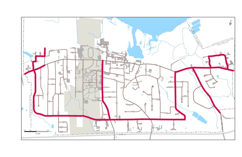
STREETS IDENTIFIED FOR PROJECT
Community Participation
This is a true community initiative. Residents play a key role by hosting sensors and helping create a richer understanding of local mobility
To participate, a location needs:
Participants can also explore their own data, compare streets, and engage with other users through the Telraam community platform.
Why It Matters?
Telraam supports better, evidence-based decisions for:
Open Data, Shared Insight
All Telraam data is openly accessible. This means:
In Summary
Telraam combines smart sensors, AI, and community participation to create a clearer, more human understanding of how our streets function. It helps move from occasional traffic counts to continuous, real-world insight — supporting safer, more connected, and more livable communities.
To get more information on the Safer Streets Pilot Projects visit Wolfville Blooms.