100 km of cycling infrastructure. One monitoring network.
How CA Béthune-Bruay measures real-world modal shift across an entire intercommunal cycling programme

Key information
- Sensor and data hosting
- Sensor installations
- Long-term monitoring
- Infrastructure implementation (bike lanes, ...)
Monitoring that matches a strong political commitment
In September 2024, CA Béthune-Bruay Artois Lys Romane formally adopted its Intercommunal Cycling Network through a deliberation of the Community Council. The programme plans 25 priority routes in the first phase (100 km), with an estimated investment of €20M, an overall objective of 200 km, and a cycling modal share target of 8% by 2030 a target enshrined in the Urban Mobility Plan (PDU) and carried by Artois Mobilités (the mobility organising authority).
To account for this commitment, the agglomeration needed a monitoring system capable of:
- Measuring actual usage of each route before and from the moment of opening, and tracking its evolution over time
- Quantifying modal shift — not just counting cyclists, but simultaneously observing the evolution of all modes at the same location
- Adapting to the construction schedule, without requiring advance planning of measurement locations
- Covering diverse environments: dense urban areas, peri-urban routes, dedicated infrastructure
Traditional counting solutions — pneumatic tubes, inductive loops, specialist counters — did not meet all of these needs: they require civil works, remain fixed, and rarely measure all modes from a single observation point.
Multimodal monitoring to measure true modal shift
Modal share measurement is only reliable if all modes are observed simultaneously, at the same location, using the same method. Combining a cycling counter on a cycle path with a motor vehicle counter on the parallel road means comparing two incompatible sources — two different locations, two distinct methodologies. Telraam counts up to 10 transport categories from a single observation point: cyclists, pedestrians, cars, light trucks, heavy vehicles, motorcyclists and more. If the cycling modal share increases on a given segment while motor traffic decreases at the same location, that is true modal shift. For a local authority committed to a quantified target by 2030, this is the only way to validate its trajectory, evaluate its projects and make the case to funders.
Dynamic deployment — no road works, repositionable
Telraam sensors install on existing street furniture — lampposts, signage poles, building facades — without trenching, without connection to the electricity grid, without requiring specific road permits or intervention from technical services. A sensor can be operational in under an hour. This agility is critical for a cycling programme under active construction: sensors can be deployed as soon as an infrastructure opens, whether temporary or permanent — as during the autumn 2025 pilot phase, where a temporary scheme converting a motor lane into a bidirectional cycle path was monitored from its very first day of operation. And once a location has been monitored for 2 to 3 years and a solid baseline has been established, the sensor can be physically relocated to a new priority route. The same hardware investment thus serves several successive routes, throughout the construction programme.
A mixed fleet, a single dashboard
An intercommunal cycling network crosses very different environments: town centres with continuous built fabric, open routes, greenways or segregated paths often set back from the road. Telraam offers two complementary sensor types, unified in a single dashboard with the same counting methodology. Indoor sensors install from a window in dense urban areas — ideal for establishing long-term baseline data in residential streets, and deployable through citizen participation or collaboration with municipalities. Outdoor sensors cover open sections and dedicated infrastructure. This mixed fleet allows direct comparison of a greenway segment and a residential street without methodological bias, and progressively extends network coverage without proportional hardware cost.
A three-phase support programme, aligned with the construction schedule
Telraam worked with the sustainable mobility team at CA Béthune-Bruay to design a progressive deployment strategy, aligned with the construction calendar and linked to the routes of the intercommunal cycling network.
- Phase 1 — Autumn 2025 / Winter 2026: Pilot deployment of 3 outdoor sensors on a priority temporary cycling scheme — a motor lane converted into a cycle path, monitored from its first day of operation. Objective: validate the solution in real conditions, establish baseline data from opening day, and train the team on the network dashboard.
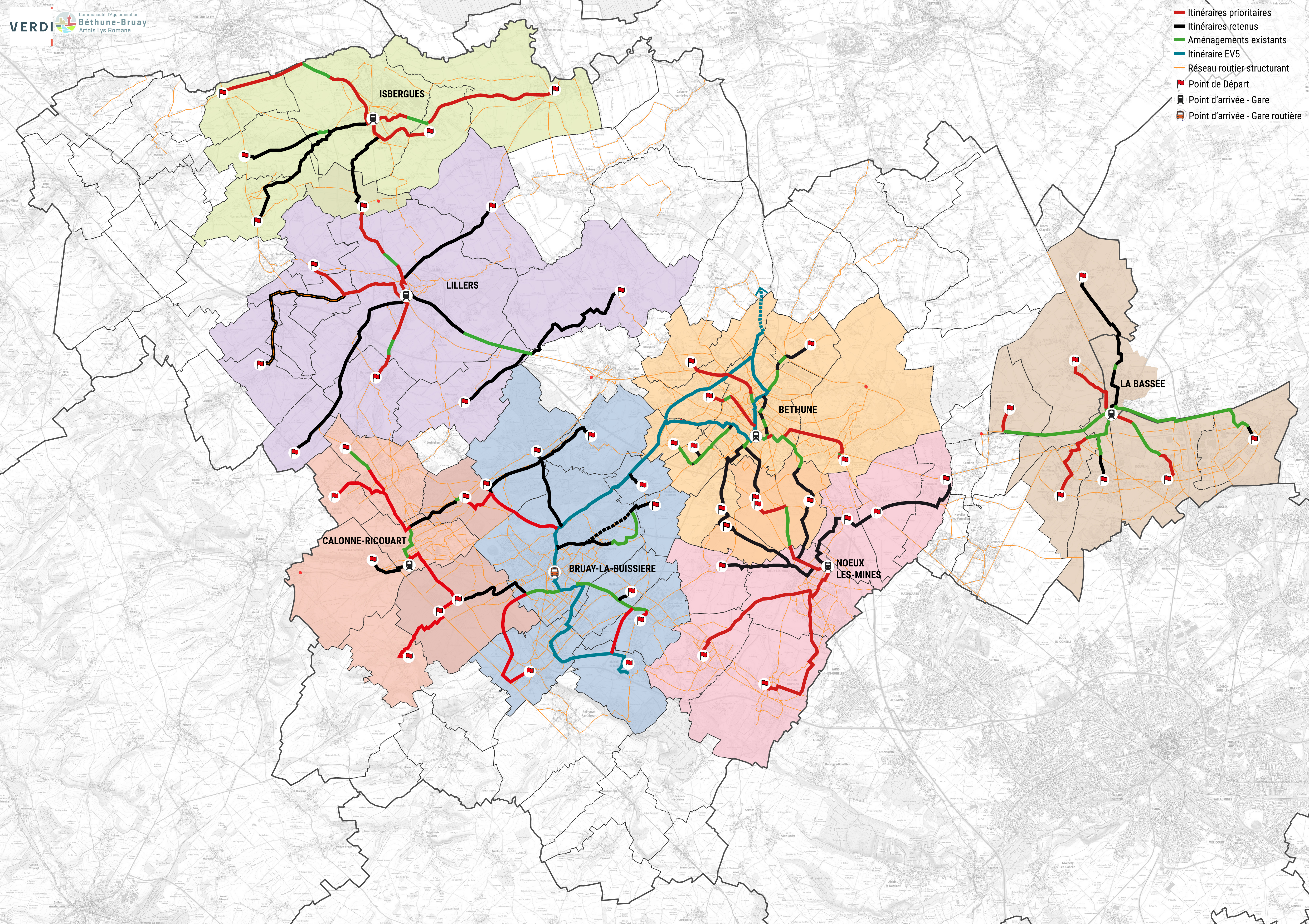
- Phase 2 — Spring 2026: Extension to 15 additional locations, bringing the network to 18 outdoor sensors covering the key intercommunal routes across the 7 living areas: Béthune, Bruay-la-Buissière, Lillers, Isbergues, Noeux-les-Mines, Calonne-Ricouart and La Bassée.
- Phase 3 — Autumn/Winter 2026: Citizen participation initiative and collaboration with municipalities for the installation of indoor sensors by volunteer residents or in municipal buildings, to consolidate the sensor network across the territory and strengthen data coverage on the intercommunal cycling network — extending coverage to residential streets and the first and last kilometres of each route.
At each phase, Telraam supported the team in selecting locations (using the Telraam outdoor placement tool), configuring sensors, getting to grips with the network dashboard, and ongoing technical support.
A monitoring network that grows with the territory
In spring 2026, CA Béthune-Bruay operates one of the largest Telraam networks in France — 18 outdoor sensors active across the territory, with a third citizen participation phase to come. The network provides:
- Continuous 24/7 monitoring at 18 strategic points on the intercommunal cycling network — with daytime multimodal counting and night-time motorised traffic detection
- Before/after data for each route at opening, enabling direct measurement of the impact of each infrastructure scheme
- A unified modal breakdown — cyclists, pedestrians and vehicles on the same segment, using the same method — directly usable for PDU reporting and regional and European funding applications
- An active redeployment plan: sensors from the pilot phase are relocated as construction progresses
CA Béthune-Bruay now has a monitoring methodology that is durably compatible with a long-term infrastructure programme: a sensor network that grows with the cycling network, without advance planning constraints, and that generates value at every stage of a decade-long construction programme.
Key figures
- 18 outdoor sensors deployed across 7 living areas (phases 1 & 2)
- 100 km of intercommunal cycling network planned (Artois Mobilités masterplan)
- 3 deployment phases — pilot, full outdoor deployment, citizen participation and collaboration with municipalities
- 8% cycling modal share target by 2030 (PDU)
- €20M infrastructure investment (phase 1) supported by continuous counting
- 0 road works required for sensor installation or redeployment
What our client says
"The Agglomération chose Telraam sensors for their ease of installation, flexibility and low cost compared to traditional counting systems. The sensors make it possible to quickly obtain data for various modes of travel, from motor vehicles to active modes.
The ability to relocate sensors means we can monitor infrastructure as it evolves and focus on the most relevant areas at each stage of our projects.
Finally, the dashboards we obtain are used to support our evaluations of the cycling network, providing before-and-after count data. This data also feeds into exchanges with elected officials and helps strengthen certain sustainable mobility policies."
Léa Duhain, Mobility Project Officer, CA Béthune-Bruay Artois Lys Romane — lea.duhain@bethunebruay.fr — +33 6 72 17 93 52
Want to know more about this project?
Feel to free to get in touch.