Making the case for safer streets in Baltimore, MD (USA)
How a neighbourhood came together to monitor their streets for evidence to improve safety
Informations clés
- Capteurs et hébergement des données
- Suivi à long terme
- Engagement citoyen
- Sécurité routière
Mount Vernon is a historic Victorian neighbourhood, now in central Baltimore, laid out originally as a place for mansions and public spaces at a time where walking was the default. However, like many US cities, its wide boulevards were adapted in the 1950's & 60's to move commuter traffic in and out of downtown. The Mount Vernon-Belvedere Association (MVBA) installed ten Telraam S2 sensors in residents' windows to measure how those streets perform today. Twelve months of counts became the Mount Vernon Traffic Action Project, a public report developed in partnership with the cycling advocacy group Bikemore, with requests to Baltimore City (link below) to address 5 areas of concern with street design and enforcement.
Client need / objectives
Residents of Mount Vernon (pop. 10,000) had long reported fast traffic, heavy vehicles on residential blocks and frequent crashes. Half of the streets studied sit on Baltimore's draft High-Injury Network, and city records show 35 crashes causing death or serious injury inside the study area between 2019 and 2023. The MVBA's Safe Streets & Transportation Committee needed local, continuous evidence to bring to the city, rather than anecdote or occasional manual counts.
The project had four objectives:
- Measure speeding on every main street, against both the posted limit and a 25 mph safe speed.
- Quantify heavy vehicles, including trucks using blocks that are not designated truck routes.
- Count people walking and cycling to show how the streets are used beyond driving.
- Test official volume estimates against measured counts, to judge whether the streets have room for redesign.
Ultimately, the goal is to return the neighbourhood to a safe and welcoming streetscape that is open to all residents and visitors, whether driving, cycling or walking.
Telraam's role
Telraam supplied ten S2 sensors and hosted the data. Volunteers mounted one sensor in a window on each of ten blocks.
Each sensor counts road users by type and direction and measures vehicle speeds in daylight. No images, video, faces or licence plates are stored. Each counter has a public page on telraam.net, so residents and city staff can check the figures for themselves.
The Bikemore team combined Telraam data with posted speed limits from OpenStreetMap, Baltimore City DOT crash records, MTA bus ridership and MDOT traffic volume estimates.
Outcome
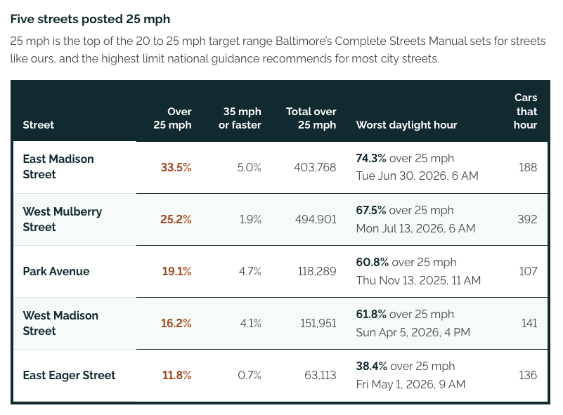
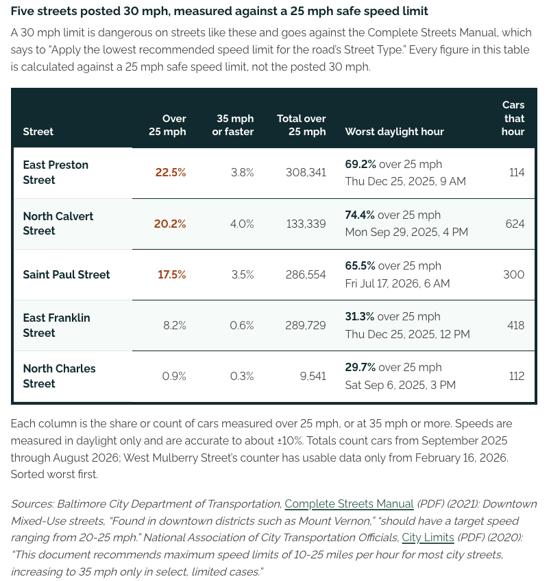
The data showed speeding on almost every street. On East Madison Street, posted at 25 mph, 33.5% of cars exceeded the limit: about 1,120 cars a day, 171 of them at 35 mph or more. In the worst single daylight hour, 74% of cars on East Madison were over the limit.
Other findings:
- Streets carry a fraction of the traffic they were built for: 8 out of 10 streets carry under 10,000 vehicles a day. All are below the 20,000 threshold the Federal Highway Administration uses to screen streets for road diets.
- About 1,092 vehicles a day on East Madison are larger than a car (24.7% of traffic), including around 300 trucks on a block that is not a truck route.
- On average, about 1,840 walking and cycling trips a day passed the sensors in daylight.
- Measured volumes were well below state estimates on several streets. West Madison carried 4,222 vehicles a day against an MDOT estimate of 11,452.
The MVBA published the findings with five requests to the city:
- 25 mph limits on every street (20 mph where possible),
- full-time red bus lanes on North Charles and Saint Paul Streets,
- closure of the southbound I-83 exit ramp at Saint Paul and Mount Royal,
- quick low-cost safety measures on High-Injury Network streets,
- enforcement of truck routes.
Conclusion
"The newly collected data proves that still in 2026 the structural flaws identified decades ago continue to threaten the community, its economic vitality, the Mayor’s Downtown Rise initiative, and Baltimore’s Renaissance. The Mount Vernon community urges city transportation officials and elected representatives to act on these decades of research by returning the streets to the people who live, walk, and visit here." - Anna Mabrey, Vice President, MVBA
Ten window sensors gave a volunteer-run association a full year of street-by-street evidence, measured by residents on their own blocks. The report pairs that evidence with city crash records and state traffic estimates, and turns it into specific, prioritised requests. The sensors remain in place, so the MVBA will continue to track any changes the city makes.
The full report is available at traffic.mvba.org
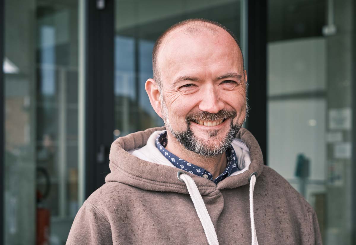
Cover photo courtesy of MVBA; "Calvert Street looking North from about Madison Street"
Vous souhaitez en savoir plus sur ce projet?
N'hésitez pas à nous contacter.